

Be sure to check the dates for the latest local dive condition data!
If you have an update on conditions, please notify us. Thank you!
Colorado Dive Conditions
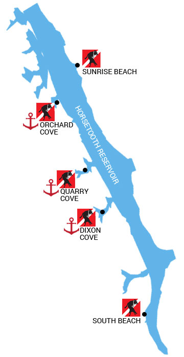
Horsetooth Reservoir
Larimer County requires you to submit the scuba diver form 24 hours ahead of your dive.
See Larimer County Website.
See local requirements posted by Larimer County. Items of note: all divers must have a buddy, buoy with dive flag and must call the ranger ahead of time. Boats are required to have both Alpha and Diver Down flag.
Prepare for limited visibility diving and cold water diving. If you are not certain of your abilities or equipment, contact a local dive expert or dive guide to ensure your safety.
Mobile users: scroll right or turn your phone
| Date | Dive Site | Surface | Thermocline | Temp | Vis | Sights | Notes/Cautions |
| Sep 2026 | Sunrise Beach | 70F | 17′, 30′ | 70/62/56 | 5′-10′ | Trash, engine block | Heavy public usage, browned out most of the time. |
| Aug 2026 | South Beach | 72F | 10′ | 75/72/68 | 0-5′ | Mud, rocks, fishing line | Low water, heavy public usage, browned out most of the time. |
| Aug 2026 | Dixon Cove | 70.8F | 10’/25′ | 72/70/68 | 0-10′ | Rocks, SMB | Low water levels, heavy boat traffic. |
| Aug 2026 | Quarry Cove | 70.5F | 10’/25′ | 72/70/68 | 0-10′ | SMB, rocks, beer cans, CC. | Low water levels, heavy boat traffic. |
| Aug 2026 | Orchard Cove | 70.8F | 10’/25′ | 72/70/68 | 0-5′ | CC, jig heads, plastic trash. | Low water levels, heavy boat traffic. |
| Sep 2026 | Santanka | 70F | 10’/25′ | 70/62/56 | 5′ | Smallmouth bass, crayfish | Low water levels, heavy paddle craft traffic, dogs overhead, |
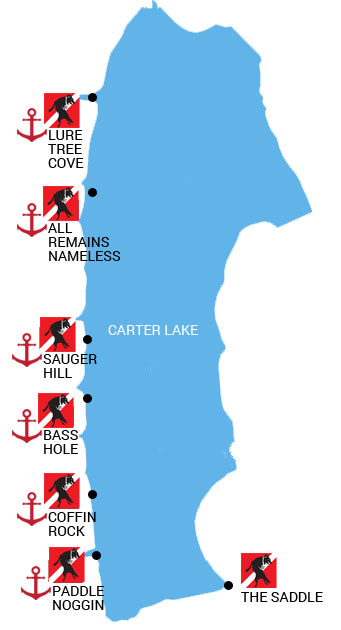
Carter Lake
Larimer County regulations and ranger contact changing Mar 2025.
See Larimer County Website.
See local requirements posted by Larimer County. Items of note: all divers must have a buddy, buoy with dive flag and must call the ranger ahead of time. Boats are required to have both Alpha and Diver Down flag.
Recommended for west shore: big bright yellow buoy with rigid flag holder.
Note: most boaters and paddleboarders do not know what a dive or alpha flag is, watch your head before surfacing.
Prepare for limited visibility diving and cold water diving. If you are not certain of your abilities or equipment, contact a local dive expert or dive guide to ensure your safety.
Mobile users: scroll right or turn your phone
| Last Updated | Dive Site | Surface | Thermocline | LowTemp | Vis | Sights | Notes/Cautions |
| Sep 2026 | Saddle | 70F | 10′, 23′, 32′ | 58F | 2-10′ | bass, sauger, walleye, crawdads, arctic grayling | Water level super low, muddy, stirs up fast. Heavy public traffic due to lake closures. Loud beach area during weekends. Damaging afternoon gusts on shore. |
| Jul 2026 | Bass Hole | 68F | 18′, 32′ | 49F | 10′-25′ | crawdads, small perch, small bluegill, walleye schools | Thermocline: clear on top, murky on bottom. |
| Jul 2026 | Coffin Rock | 71F | 12′ | 59F | 8-10′ | trout, crawdads | Thermocline: clear on top, murky on bottom. |
| Jul 2026 | Lure Tree Cove | 65F | 17′ | 49F | 10-15′ | smallmouth bass, crawdads | Harsh thermocline: clear on top, murky on bottom. |
| Jul 2026 | Sauger Hill | 58F | 23′ | 56F | 10′-20′ | small fish in rocks, walleye schools | Thermocline: clear on top, murky on bottom. |
| Jul 2026 | Paddle Noggin Point | 72F | – | 56F | 8-10′ | crawdads | Thermocline: clear on top, murky on bottom. Heavy fishing traffic. |
| Sep 2026 | North Pines Trailhead | 68F | 17 10′, 23′, 32′ | 56F | 5-10′ | crawdads, rainbow trout, walleye, bluegill | Clear, boat ramps open, watch for boats. Heavy fishing traffic. |
| Jun 2026 | All Remains Nameless | 58F | 17′ | 56F | 10-15′ | perch, crappie, walleye, auger, smallmouth bass, rocks. | Thermocline: clear on top, murky on bottom |
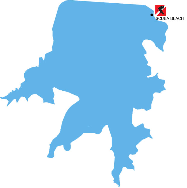
Aurora Reservoir
See local requirements posted by Aurora. Items of note: all divers must have a buddy, buoy with dive flag and must call the ranger ahead of time. Boats are required to have both Alpha and Diver Down flag.
Long paved walk into Scuba Beach. Very nice picnic area and lockers (bring your own lock) are available.
Mobile users: scroll right or turn your phone)
| Date | Dive Site | Surface | Thermocline | Temp | Vis | Sights | Notes/Cautions |
| May | Scuba Beach | 54F | Unremarkable | 54F | 10′ | Airplane, WE, SG, CC Chironomids rising, crayfish hatch, water bugs, egg sacs. | Lots of random lines going in every direction. Trust your compass, check your air. Getting lost, stirring up the bottom, low vis. |
Out of State Nearby Dive Sites
Mobile users: scroll right or turn your phone
| Date | Location | Dive Site | Surface | Thermocline | Temp | Vis | Sights | Notes/Cautions |
| Sep | Midway, UT | Homestead Crater | 93F | — | 97F | 15-20′ | Scuba divers, swimmers, wagon wheel, alligator, skeleton with PPE | Look up before going up! |
| Aug | Santa Rosa, NM | Blue Hole | 63F | — | — | 40′ | Scuba divers, loads of crawdads | OPEN with new wall restrictions. Under construction for addition to community center. |
| Sep | Flaming Gorge, UT | Cart Creek Bridge | 68F | 18′ | 59F | 20′ | Walls, slight current, SMB, fishing tackle/line, rope. | 6053′ Altitude dive! (mean 212) Watch your ascent/time, driving over passes. Fisherman, boats topside. Cliff jumpers, paddleboarders, kids and dogs. Steep hike down trail – 100 yards +. Loose rock. |
| Sep | Flaming Gorge, UT | Mustang Ridge | 68F | 25′ | 60F | 25′ | Rock walls, loads of fishing line, garbage. SMB | 6359′ Altitude dive! (mean 212) Watch your ascent/time, driving over passes. SMB, heavy paddleboard traffic. Easy shore entry, parking fee. Multiple thermoclines. |
| Sep | Flaming Gorge, UT | Sunny Cove | 70F | 18′ | 62F | 15′ | Rock walls, loads of fishing line, garbage. SMB | 6359′ Altitude dive! (mean 212) Watch your ascent/time, driving over passes. Trout, SMB, boat traffic, stay away from dock/ramp.Easy shore entry, parking fee. |
| Sep | Flaming Gorge, UT | Osprey Island | 68F | 30′ | 60F | 25′ | Rock walls, slot canyons, turbine sounds on the dam side, caverns. SMB. | 6053′ Altitude dive! (mean 212). Boat dive best, or a long swim through boat traffic. 30′ rope will take you to slot canyons. |
Dive Site Sights Key
CC: Crawdads/crayfish
SMB: Small mouth bass
WE: Walleye
SG: Sauger
RBT: Rainbow Trout
LMB: Large mouth bass
SB: Striped bass